Fall 2017
Mentor: Dr. Frank Ettensohn
DESCRIBING THE HISTORY AND ORIGIN OF CARBONATE MUD MOUNDS IN SOUTHERN KY
The objective was to determine the history and origin of facies present in a specific carbonate mud mound outcrop in south-central Kentucky. By integrating our knowledge of the regional geological history of the Neoacadian Orogeny, concepts of basement uplift and sea level transgression, and sediment delivery mechanisms that might have existed in the channel at the time of deposition, we could incorporate field observations to determine the origin of the structure. Field observations involved characterizing representative sections of the outcrop, measuring, describing, and photographing the exposed area. Sedimentological, paleontological, and stratigraphic data including lithologies, biogenic structures, fossil fragments, and textures were carefully noted. The field notes were used to develop a representative stratigraphic column.
Study Site
Map of faults in eastern to south central Kentucky. Stops 9 and 10 mark approximate location of Burkesville outcrop. NW-SE trending faults are Precambrian in age and were reactivated by later orogenies. (Ettensohn et. al., 2012)
South-central Kentucky
~8.5 miles N of Burkesville, KY
Latitude: 36° 54′ 0.6″ N; Longitude: 85° 25′ 46.74″ W
Objective: Determine history and origin of facies present in the carbonate outcrop
Geologic Setting & Paleoclimate
Neoacadian Orogeny
Basement Uplift
Sea Level Transgression
Sediment Delivery via Borden Delta Channel Network
- Environment changed with adjusted sea level evident by multiple mud mounds “stacked” separated by glauconitic shales
- Mounds thicken on flanks due to storms wiping away tops of mounds and depositing crinoid debris in low stable areas
- Syntectonic deposition as noted by less displacement up-section and angular unconformity at bottom contact of larger mud mound
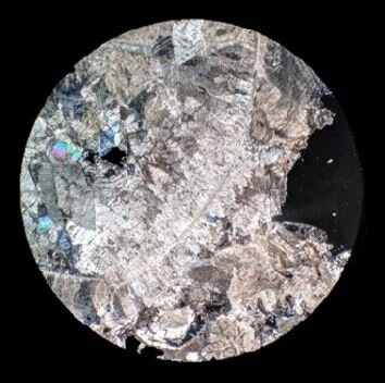
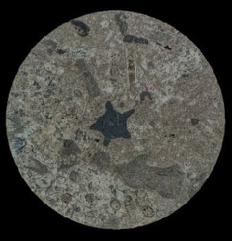
Thin Section Evidence


Conclusions
Regional effect of tectonics caused flexure and foreland basin development with associated foreland bulge due to subducting plates in the east
Rising of basement floor closer to photic zone allowed some sediment bafflers to establish in substrate at the inception of basin formation
The formation as a whole developed just before the delta complex completely was abandoned after a long phase of intermittent sea level regression
An alternate hypothesis could be that the mounds are deep water chemotrophs, but there is less evidence in this from the facies
A second alternative hypothesis is that these could be associated with turbidity currents that escape slope channels and got reworked by other currents into mounds
References
Ettensohn, F.R., Lierman, R.T., Udgata, D.B.P. and Mason, C.E., 2012, The Early-Middle Mississippian Borden-Grainger-Fort Payne delta/basin complex: Field evidence for delta sedimentation, basin starvation, mud-mound genesis, and tectonism during the Neoacadian Orogeny, The Geological Society of America Field Guide, v. 29, p. 345-395.
Greb, S.F., Potter, P.E., Meyer, D.L. and Ausich, W.I., 2008, Mud Mounds, Paleoslumps, Crinoids, and More: the Geology of the Fort Payne Formation at Lake Cumberland, south-central Kentucky, Kentucky Chapter of the American Institute of Professional Geologists Field Trip Guide, p. 1-45.
Paleogeographic map showing Borden Delta Complex and location of shoreline during Early and Middle Mississippian (Ettensohn et. al., 2012)
Stratigraphy of Fort Payne Formation and accompanying units (Greb et. al., 2008)
KY Highway 61 runs parallel to outcrop.
Field Evidence
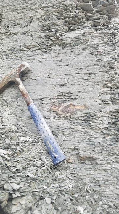


Credit: Clay Seckinger